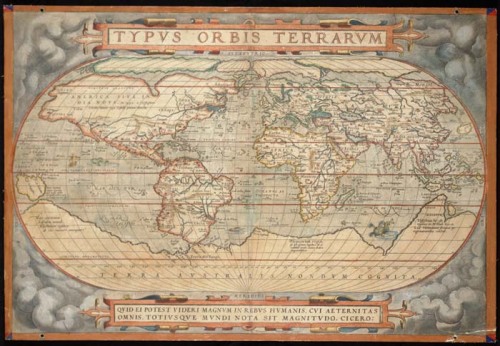
Mapping Colonial Latin America: Typvs Orbis Terrarvm (1570)
Unlike the Cholula map I discussed in the previous post, I chose the other map for the header without the Spanish/Latin American context particularly in mind. In fact, the map was produced by a Flemish mapmaker named Abraham Ortelius in 1570 as part of a work considered to be the first modern atlas. Nonetheless, juxtaposed with the Cholula map, Ortelius’s Typvs Orbis Terrarvm map is quite revealing with regards to the colonial encounter from the European point of view. As part of the first modern atlas, the Typvs Orbis Terrarvm reflects the impact of the discovery of the Americas on the emergence of a modern European cosmovision. In particular, it represents an intermediary stage in the emergence of a rationalized, geometricized conception of global space as a consequence of what Eugene O’Gorman calls the Invention of America.

The reason America had to be “invented” rather than merely discovered is that Europe in the 15th century was still dominated by a mythological world view. Even in 1492 European cosmography remained under the spell of the medieval “T-O map,” pictured at the right, which divided the world into three discrete parts (Europe, Asia and Africa) centered around Jerusalem, with each part corresponding to the domain granted by God to a particular race – the descendants of each of the three sons of Noah.
Columbus’s arrival in the New World, though initially filtered through the misinterpretation that he had arrived on the eastern coast of Asia, gradually disrupted the tripartite worldview of the T-O map because it introduced a fourth part of the world which could not be incorporated into the mythological schema. Forced to abandon the model of a world divided into a discrete number of parts, European cosmography in the 16th century adopted instead a homogenized, geometrical conception of space organized around Ptolemy’s grid of latitude and longitude. At the same time, Europe gradually gave up the notion of the world as a limited space assigned to man by God in favor of a limitless world over which man (and, in particular, European man) was sovereign.
Ortelius’s world map of 1570 shows the process of filling in the grid at work. Notice in particular the relative accuracy of the vertical dimensions of the map, in contrast to the rather distorted horizontal dimensions. By 1570, European cosmographers had perfected a method of measuring latitude, but a reliable method for measuring longitude was slower in coming. López de Velasco attempted to include with his geographical survey instructions for a process involving measurements of the location of the moon during an eclipse, but the colonial officials who received the instructions were either apathetic or inadequately trained to perform the tasks with any degree accurately, if they performed them at all.
As in the Relaciones Geográficas map of Cholula, the gridlike structure of Oretelius’s world map as a framework exceeds the information with which it is filled in. Both maps bare witness to a moment when the grid signifies only itself, when the imposition of grid lines, meant to facilitate the ideal of a mimetic, one-to-one correspondence between the geography of the map and the geography of the landscape, comes instead to mark the very ideality of the grid in the European imagination.


